Log in
All resources
Create a design
5,876 Free Artworks of Image Map
maps in the library of congress
description de l'universe
alain manesson mallet
1685 maps of europe
historical images of lucknow
edward weller
old maps of lucknow
19th-century maps of southeast asia
maps from the earth and its inhabitants, vol. ix
picturesque burma, past and present (1897)
maps in the library of congress
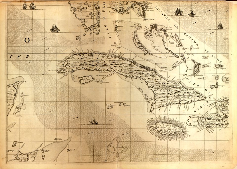
1639 maps of cuba
turgot map of paris, kyoto university library – derivative files
lycée henri-iv
japanese prints in the metropolitan museum of art
yokohama-e by utagawa sadahide
john rocque's 1746 map of london
old and new london (book)
a map of the british empire in america with the french and spanish settlements adjacent thereto
maps in the library of congress
historical images of the saint george complex in lydda
van de velde, 1857
maps from the earth and its inhabitants, vol. viii
buddhist pilgrimage sites in india
maps of the holy land by mercator-hondius
maps in the library of congress
untrodden peaks and unfrequented valleys (1873)
old maps of the alps
untrodden peaks and unfrequented valleys (1873)
maps of south tyrol
a map of the british empire in america with the french and spanish settlements adjacent thereto
maps in the library of congress
maps by joachim bormeester
1680s maps of the world
historical images of lucknow
edward weller
historical images of lucknow
edward weller
historical images of lucknow
edward weller
historical images of lucknow
edward weller
map collection of leibniz-institut für länderkunde
maps of spain by tomas lopez
map collection of leibniz-institut für länderkunde
maps of spain by tomas lopez
dr. wilh. junker's reisen in afrika 1875-1886
1880s maps of sudan
maps from university of amsterdam special collections
atlas der neederlanden
map of the german empire by louis stanislas d'arcy de la rochette
1782 maps of the holy roman empire
australia (1873) by booth
1870s maps of australia
maps of budapest by braun & hogenberg
16th-century fortress plans
truscott map of st-petersburg 1753
engraved maps of saint petersburg
historical images of the festung ehrenbreitstein
baroque
squier and davis images
hopeton earthworks
19th-century maps of the malay archipelago
the cruise of the marchesa (1889)
map of paris by claes jansz. visscher - derivate files
historical images of abbaye de saint-germain-des-prés
maps from the earth and its inhabitants, vol. xiii
maps of telegraph lines
maps from the earth and its inhabitants, vol. xvi
1870s maps of panama
maps from the earth and its inhabitants, vol. iii
linguistic maps of the balkans
maps from the earth and its inhabitants, vol. vii
maps of the mongol empire
maps from the earth and its inhabitants, vol. vi
maps of weather and climate of asia
maps from the earth and its inhabitants, vol. ix
maps indicating exploration
maps from the earth and its inhabitants, vol. v
1870s maps of russia
maps from the earth and its inhabitants, vol. ix
1870s maps of jerusalem
maps from the earth and its inhabitants, vol. xiii
maps indicating exploration
maps from the earth and its inhabitants, vol. viii
1870s maps of india
maps from the earth and its inhabitants, vol. v
1870s maps of norway
maps from the earth and its inhabitants, vol. iii
1870s maps of belgium
maps from the earth and its inhabitants, vol. xvi
1870s maps of panama
maps from the earth and its inhabitants, vol. vii
1878 maps of asia
maps from the earth and its inhabitants, vol. xi
1870s maps of tunisia
maps from the earth and its inhabitants, vol. vi
maps of the history of russia
maps from the earth and its inhabitants, vol. ix
1870s maps of jerusalem
maps from the earth and its inhabitants, vol. viii
1870s maps of india
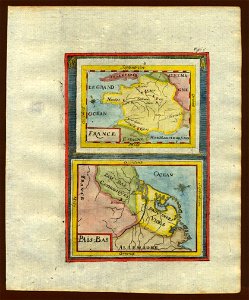
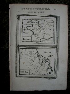
17th-century maps of france
description de l'universe
17th-century maps of france
description de l'universe
old maps of whole wales (alone)
description de l'universe
1680s maps of baden-württemberg
description de l'universe
1680s maps of lower saxony
description de l'universe
17th-century maps of the iberian peninsula
description de l'universe
description de l'universe
1680s maps of scotland
description de l'universe
1680s maps of ireland
17th-century maps of france
description de l'universe
17th-century maps of italy
description de l'universe
maps in the library of congress
1713 maps
turgot map of paris, david rumsey historical map collection – derivative files
historical images of luxembourg palace
picturesque burma, past and present (1897)
1890s maps showing history
picturesque burma, past and present (1897)
1890s maps showing history
picturesque burma, past and present (1897)
1890s maps showing history
picturesque burma, past and present (1897)
19th-century maps of myanmar
la palestine (1883, by chardin)
travel maps of palestine
the earth and its inhabitants, vol. vi: asia, vol. i
title pages of books about geography
mechanicsville historic district
maps in the library of congress
historical images of église saint-nicolas-du-chardonnet
map of paris by braun & hogenberg - derivative files
18th-century french nautical charts
historical images of souda bay
maps from the earth and its inhabitants, vol. ix
old maps of the holy land
endrei zalán: a világ történelme
1900s maps of india
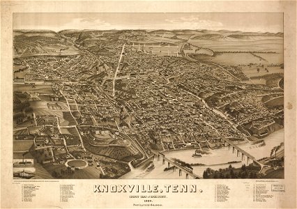
bird's eye view of knoxville, tennessee, 1886
maps in the library of congress
maps in the library of congress
cartouches by tomas lópez
1700s maps of germany
battle of blenheim
old maps of el hierro
history of el hierro
maps of archaeological sites in italy
storia degli antichi popoli italiani
historical images of palais bourbon
plans of castles in france
maps from the earth and its inhabitants, vol. iv
halifax, yorkshire
corona and coronet (1898)
1898 maps of the world
maps in the library of congress
1690s maps of the world
maps in the library of congress
1773 maps of the united states
maps from the earth and its inhabitants, vol. xv
exploration of the arctic
description de l'universe
old maps of karpathos
1870s maps of libya
ghadames
maps of cochem by braun & hogenberg
baroque
travel maps of the united kingdom
australia (1873) by booth
maps in the library of congress
1755 maps
maps in the library of congress
old maps of antigua and barbuda
historical images of parvis notre-dame - place jean-paul ii
notre-dame de paris on the maps
algiers in the 16th century
martino rota
turgot map of paris, david rumsey historical map collection – derivative files
historical images of the hôpital de la pitié-salpêtrière
maps from the earth and its inhabitants, vol. vi
latin-language maps
maps from the earth and its inhabitants, vol. xvii
anton francesco lucini
old maps of tierra del fuego
description de l'universe
17th-century maps of the iberian peninsula
description de l'universe
17th-century maps of south america
description de l'universe
maps in the stadsarchief amsterdam
die grund-regeln der bau-kunst
bird's eye view of knoxville, tennessee, 1886
maps in the library of congress
asia noviter delineata
java in art
too late for gordon and khartoum (1887) by macdonald
old maps of the nile
17th-century maps of the mediterranean sea
maps in the library of congress
the gazetteer of scotland (1838)
william home lizars
501 - 600 of 5,876
Next page
/ 59

![[Map of the complete island of Cuba]., Johannes Vingboons, 1639](https://cdn.creazilla.com/illustrations/6627474/map-of-the-complete-island-of-cuba-loc-2003623399-illustration-sm.jpeg)